 |
|
AS50 Map ChallengeAS50 Map Challenge: Mapping the Kingdom of Lochac from Large to Small:
[T-O and Zonal Maps]
[Itineraries and Route Maps]
[Local Maps]
[Isolario ¢ Mapping Islands]
[Kingdom and World Maps] I have an AS50 Challenge to produce 50 different maps. IÆve been collecting map information for a long time now, but IÆve been hoping that the AS50 Challenge will help motivate me to get on with actually producing the maps. IÆve found it easiest to do when we are on our regular holiday as it means fewer distractions and a better set-up for the drawing and calligraphy/handwriting required. In one creative week's burst I started on around 25 maps, even finished some (which are seen here), but came to a grinding halt with the earthquake era starting in February 2011. After a hiatus of far too long, IÆm hoping to get back into it and meet the Challenge with plenty of time to spare. Wish me luck!
T-O and Zonal MapsAmongst the earliest maps on record are ones termed T-O maps, named as such because they divided the world into a T-shape surrounded by a circle, or O.
T-O maps show three land masses, Europe, Asia and Africa, which are separated by the T formation representing the major water bodies and surrounded by the O of the Mare Oceanus, the huge ocean thought to encircle the world's nether regions. (Livingstone points out that the flat disk shape is merely convention and not reflective of the map-maker's belief in a flat earth; the T-O map simply represents the non-watery hemisphere where the important places lie.) �The T itself has three main sections. The upright of the T represents the Mediterranean, which separates Europe from Africa. The cross-bar of the T was typically held to represent the Red Sea or sometimes the Nile separating Asia from Africa (on the right) and the important waterways of the Black Sea, the Don or Tanais River and the Sea of Azov (on the left of the cross-bar). The orientation was traditionally shown with east at the top of the map, as this was thought to be the direction of Paradise. A number of T-O maps have Paradise noted at the top, with Jerusalem at the centre. Many T-O map conventions were based on the work by St Isidore of Seville (600-636), the Etymologiarum sive Originum libri XX. The first known printed map in Europe is a T-O map, printed by Gunther Zainer in 1472, and they continued to be printed through until the 17th century as part of atlases and works of knowledge. A T in an O gives us the division of the world into three parts. The T-O convention works quite well for depicting my part of the Known World, with the Tasman Sea and Cook Strait forming obvious analogues to the Mediterranean Sea and Red Sea, dividing the Kingdom into three parts: Continental Lochac (Australia), and the Crescent Isles, being the North and South Islands (New Zealand). Zonal maps, like those by Macrobius, Foresti and others, provide another means of depicting the world, dividing it horizontally into various climatic zones, not that unfamiliar to a modern geographer. Thus the cold regions of the poles are marked, along with the temperate zones as you approach the equator. Beyond that, early cartographers believed there was an inhabitable zone of perpetual wind and heat in the southern realms. Little did they knowģ Again this concept is readily adaptable to SCA use, simply by continuing with the zonal regions whereby we agree that places too close to the equator really are uninhabitable, but civil life can prosper in the more temperate regions. T-O List Map; based on Isidore of Seville, 10th centuryThis list map would be amongst the most schematic of maps, being a collection of comments relating to various provinces. The manuscript by Isidore of Seville collects this information within a 110-mm diameter circle, divided into three as per T-O maps, but with internal text ōgrouped in a geographically suggestive wayö. (Mapping Time and Space, pg 6) Map under production
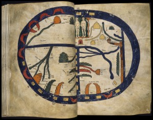
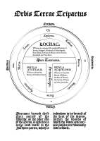
T-O World Map, based on Beatus, 11th CenturyBeatus, drawing in the 11th century, depicted the world in three parts (Europa, Africa, Asia) divided by the Mediterranean and Red Sea. Some major mountain chains are shown, and the map has Adam and Eve with the snake and the Edenic tree at the top. Surrounding the land is the world ocean in which are found a batch of oddly rectangular islands in roughly indicative locations. Map under production Zonal Map, based on Lambert of St Omer, 12th centuryThe Known World zonal map depicts the various zones, as used in LambertÆs 12th century map, updating the southern hemisphere to reflect our area of interest, and retaining the schematic representation of Europe. The scale of certain parts of the Kingdom of Lochac may be considered a trifle exaggerated, but thatÆs a cartographic choice. Map under production T-O Map: Orbis Terrae Tripartus, based on Lucan, 14th CenturyAlthough the original production of this map falls outside the AS50 timeframe, IÆve included this material here as I will be updating the map to better reflect the political geography of Lochac, as noted at the end of this section.
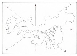
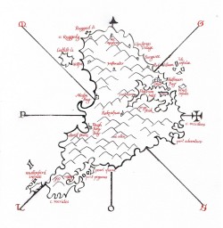
My map is based closely on a T-O map taken from the 14th-century edition of the writing of Lucan, as it contains many of the common elements of a T-O map and a layout that makes it suitable for adapting to our part of the Known Worlde. I've added a number of legends relating to the areas, as was done with the Sallust T-O maps, and implied the political as well as physical relationships, as was done with the Byzantine-Oxford maps (Siebold).
The additional winds have been added, as the cross-quarter winds, such as the nor-westerly, are more prominent in these parts. There seems some sort of irony that the South Island is rendered in Latin as Insula Australia, with Insula Aquilonis for the North Island. The orientation of the map has been adjusted to present the standard T-O look while retaining the correct compass directions; thus occidens appears at the top of the map. Many period maps had variable orientations, so this is not a problem in reproducing this style of map. Both areas are, of course, surrounded by the world sea or Oceanus, so this makes it more accurate than the originals! The commentary below the map has been adapted from a section in St Isidore's dealing with the possibility of land on the other side of the world: Moreover beyond these three partes of the Worlde, on the other side of the Ocean, is said to be a large land masse in the Northern partes, which is unknowne to us because of the heat of the Sunne, within the bounds of which the Podes and varipus peoples are fabulously said to dwell. The typeface is in JSL Ancient, as developed by Jeff Lee based on the transitional typefaces used in the latter part of the 1600s, and a close match for type used in period; JSL Blackletter has also been used. The text has been run through Lees' JSL Font Converter to produce the ligatures and special characters used at the time. AfterwordI must do a second edition of this map. That's because it is possible to read it as implying that the large continental portion of the kingdom is that which claims full use of the Kingdom name of Lochac. And while this is a common error, it's not one I wish to encourage in any fashion, as that then leaves the Crescent Islanders on the outside looking in. There's been a huge amount of debate about how and what to name the various parts of the kingdom. There are times when it becomes necessary to differentiate between the two mundane nations that make up the one united kingdom, and attempts to find suitable names for the different parts have caused all manner of discussions both academic and heated. If you'd like to know why I think that this is a very important issue, then you're welcome to take a look at the Naming Issue FAQ which was put together to try to find a solution to this very knotty problem.
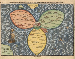
A Clover-Leaf World; Heinrich Bunting, 1588The clover-leaf world map by Henrich Bunting, printed in 1588, hearkens back to the T-O tradition, with three segments for Europe, Asia and Africa, and Jerusalem at the centre. Its concession to a more modern world view was the inclusion of America at the left-bottom edge of the map. The map lends itself to the depiction of the Kingdom of Lochac in its T-O format. Map under production Itineraries and Route MapsRoyal Route Map, 1578A schematic route map shows the planned progress for Queen Elizabeth in 1578, indicating the distance in miles between the various stops. The original hand-sketched map is 20 cm x 19 cm. (English Maps, pg 144). The Lochac Crown itinerary shows the routes in miles for Siridean and Margie's reign, from their Coronation at 12th Night in DragonÆs Bay to their divestment at Innilgard Midwinter, based on the Royal progress itinerary. Itinerario for Siridean and Margie, PDF Pilgrimage Routes; based on Matthew Paris, 1250
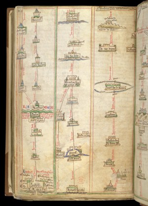
Matthew Paris produced a batch of maps during the 1200s, the best-known of which is the Chronica Majora. The route maps for pilgrims took the innovative approach of being laid out in handy strip form, with useful landmarks and each section based on roughly a dayÆs journey for the walker. The works were produced as manuscripts, in folio form, measuring 35 x 23 cm; on occasion, additional elements were stuck to the page and folded in. Colour was used to differentiate elements: the major text was inked in red or alternating red and blue; with a green wash around the buildings, blue for roofs and rivers. This style of map was used as the basis of a strip map showing how to get to Southron GaardÆs Canterbury Faire site from the north (starting in Ildhafn City) or the south (starting in St Kessog). Unlike ParisÆ maps, the journee distances do not represent a dayÆs walk, but merely space to travel between obvious landmarks. I asked a couple of regular travellers to Faire from the northern area to indicate what they used as landmarks on their journey and incorporated that into the description. Itinerarios often included descriptive information from travellers and some travel tips and advice, along these lines: The huge inland waters of Taupo must be skirted with caution as this area is home to firey mountains which cast ash and rocks upon the unwary traveller toiling over the high road that winds it way across the desert. Some talk of trolls but this writer knows not of such ungodly beasts. The map elements are based on those used by Paris, with some adaptations to reference current landmarks. The Faire site is captioned with the first few lines from ChaucerÆs Canterbury Tales.
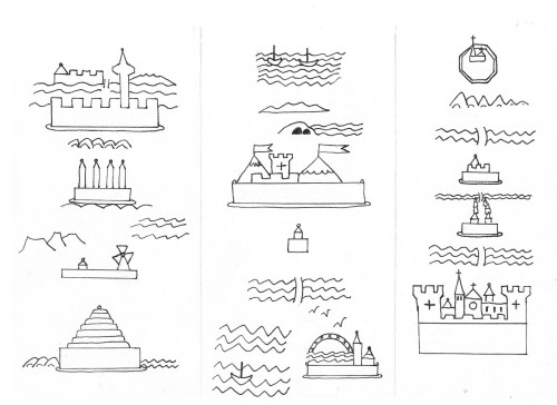
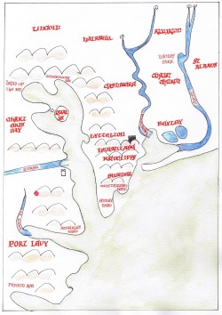
The above illustration shows the basic strip map elements for the northern and southern routes to Canterbury Faire, before the layout was finished and the text added (Lombardic font). The lefthand column reads downwards, with Auckland at the top, including Rangitoto Island and the silhouette of the Sky City, later labelled caveat emptor in recognition of the City merchant reputations. Then comes the stacks of the Huntly Power Station, the three volcanoes of the Central North Island (caveat ignis), the windmill representing the wind turbines of the Manawatu (caveat ventes), and the Beehive parliamentary building in Wellington (should have said caveat omnia!). From there, the top of the central strip shows ferries crossing Cook Strait, to start on the long coastal run past seal colonies and through narrow road tunnels to the Canterbury Faire site in north Canterbury. The southern route starts at the top right, with the Octagon in the centre of Dunedin, home to St Kessog, passing through the plains' towns of Timaru and Ashburton (the latter being a railway strip development), and crossing various large braided rivers to reach Christchurch, the main city of Southron Gaard. The Cathedral has been a city icon, standing in the centre of the town until the recent earthquakes and church-based decisions demolished it; it is flanked by the towers of Southron Gaard. The bottom of the central strip shows the Sydney Harbour Bridge, found in the Barony of Rowany, representing Continental Lochac; the birds indicate the usual travel path for people coming from there. These elements were moved, in the final production, to the left/west, as appropriate for the actual geography. The small building in the centre, above the Waimakariri River marks the Mud House, a landmark on the main north highway which is the turnoff to the Faire site. Canterbury Faire Pilgrim Itinerario PDF Local MapsIn the style of Cambrensis, 12th centuryThe map of Europe by Gerald of Wales (Giraldus Cambrensis) is one of the more recognisable ones for a modern viewer, once you understand the orientation with Rome at the top and Hibernia (Ireland) at the bottom. It remains fairly abstract with little in the way of actual coastline, concentrating more on relative positions, with indications of the major rivers. According to the History of Cartography (ChVI, pg 40), the vertical alignment is to emphasize the general closeness of the ōworldö to Rome. The map measures 21 x 17 cm. My map of Lyttelton Harbour is similar in physical size, but the scale is much smaller (the green wash much more closely matches the original in the manuscript; the scanning seems to have dropped most of the colour out). I have a Kingdom version under production.
In the style of Luis Teixeira, 1586The Roteiro of Luis Teixeira, 1586, provides a nice example of the mapping of local coastlines, in a coloured manuscript. His maps were teamed up with instructions for entering and leaving harbours and descriptions of the coastline.
In the style of Waghenaer, 1585
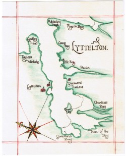
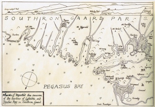
A map of the Christchurch coastal area of Pegasus Bay, including Lyttelton Harbour, based on Lucas Jansz Waghenaer's depiction of the Thames Estuary in his Sea Atlas, printed by Plantin in 1585. The soundings are in metres, based on current navigational charts; the profile of the Crater Rim hills is drawn from the viewpoint of the New Brighton Pier. By sheer luck, the scale of the coastal profile just about matches the placement of the headlands in the plane drawing section of the chart. This map was drawn by hand. I am considering scanning the elements and then fixing up some of my botches electronically, such as the lettering in the cartouche at bottom left, and adding suitable graphic elements. I haven't yet mastered the art of reproducing the ships and sea creatures found in many of the later printed maps, but hope to be able to do so, or at least to build up a set of relevant clip art to use. Then I can print it out for hand-colouring.
Ildhafn Urbis Pars, & les Isles de Hauraki, 1600The printed map of New Guinea and the Soloman Islands served as inspiration for this local amp, showing, as it does, a section of coastline and nearby islands on the one map. It has a scale bar and also shows the line of the equator passing through. This shows part of the City of Ildhafn and the Hauraki islands of the Waitemata Gulf, which have been moved west somewhat for cartographic convenience, as per the original. The text reads: The Barony of Ildhafn has a great city of merchants and pirates. There are many chariots there and the city smells. To the south in the country is the pleasant village of Cluain, but it is boring.. If youÆd like to print this map out to colour in yourself, hereÆs a PDF of it. Isolario ¢ Mapping IslandsIsolarios were maps of islands characterised by highly stylised schematic coastlines, often drawn in sweeping curves; cardinal points were indicated by letters, with an arrow for north and a cross for the east. They were generally printed as loose-leaf woodcuts, or with accompanying texts or sonnets about the islands depicted. The works were generally sized around 30cm x 20cm. Venetian cartographers seem to have been particularly keen on this distinctive style, with the likes of Benedetto Bordone, Bartolomew delli Sonetti, and Jacapo deÆBarbari producing woodcuts and books of island maps from the 1480s (Sonetti) through to the late 1500s(Antonio Millo). In the style of Bordone, 1528Bordone tended to use more place-names than other isolario cartographers and included more detail on inland cartography. He is said to have been the first to use a towered building to represent a town (Antique Maps, pg 195)
In the style of various others
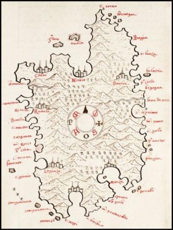
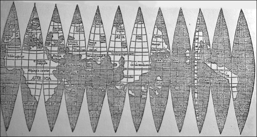
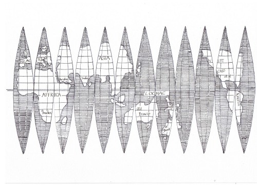
Kingdom and World MapsGiven the scales involved, I decided to concentrate most of the ōworldö maps on the Kingdom of Lochac, though some of the versions I have made do look a little further afield. I cannot but laugh when I see numbers of persons drawing maps of the world without having any reason to guide them. Rudimentum Novitiorum; based on Lucas Brandis, 1475In 1475, the Rudimentum Novitiorum was the first printed world map to depict the world in something more than a T-O format, although hints of that do remain with the watery division across the centre. It has also been described as a ōlist map with decorative elementsö (Image of the World, pg 34). Each of the ōeccentric hillsö has the name of a country or province (eg Lybya, Taprobana), starting with east (oriens) at the top. The type has been inserted into the woodblock for printing. Population appears to be indicated by the use of icons such as small towers, towns and large cities; Rome has one of the most complex icons, including a depictionof the Pope holding a cross. Map under production As with a lot of larger-scale mapping of SCA territory, the new map suffers a bit from low density of both land masses and population. The Lochac Rudimentum Novitiorum maps the Kingdom, with Continental Lochac to the left and the Crescent Isles to the right. A number of the hills are unlabelled as they are there to maintain a look comparable to the Brandis map, while still reflecting the geography of the Kingdom. The Barony of Southron Gaard, for example, encompasses the entire South Island of New Zealand, so should consist of just one hill under the original schema. In the style of Gerald of Wales, 12th CenturyMap under production The Globe in Gores, Waldseem³ller, early 1500sWaldseem³ller produced a woodcut of 12 gores in 1507 (18 x 34cm). it is one of the first maps to use the term America, applied to the southern continent. I've used this as the basis for a set of gores for a globe of the Known Worlde and, yes, I know that the Crescent Isles is well out of size but otherwise we wouldn't show up on the map at all. The Known World gores are sized to fit a standard polystyrene craft ball and one of these days I'm going to get around to making one up.
During the COVID years, the SCA announced a Known World Mapping Challenge as part of efforts to get people interacting online. I sent in an entry explaining why my map would have a different interpretation of the world the (US-based) Society knew. I never heard anything more of it, but here is the explanation I put together. Maps -- or important parts of them -- loom large in the eye of the beholder. Mercator stretched his northern latitudes to emphasise Europe; modern maps tend to centre on the Americas or, at the very least, the Atlantic framed by the Americas and Europe. I come from a country which doesn't just get pushed to the edge of the map -- it gets pushed right off it. Despite being roughly the same area as Japan, Italy or the UK, it is not uncommon for our 270,000 square kilometres -- about the size of Colorado -- to be left off maps entirely. (See John Oliver's riff on that here.) So when I map the Known Worlde, it's with my bit of it in mind. The Crescent Isles of Lochac, with its Baronies of Ildhafn and Southron Gaard are unashamedly up front. For 20 years we were known as the Southern Reaches of Caid, at a time when Continental Lochac (including its island barony of Ynys Fawr) was a Principality of the West. These lands form the centre of our SCA world. We know about the mainland kingdoms out there on the furtherest edges of our Oceania Pacifica, but only have a vague idea of where they are placed and how many there are. We have more contact with the Kingdom of Drachenwald -- their Thamesreach Shire is known more informally here as "Little-Lochac-upon-Thames" for the significant number of our citizens who reside there, half a world away but never forgotten. There are many ways to view the world -- this is us.
| |||||||||||||||||||||||||||||||||||||||||||||||||||||||||||||||||||||||||